Phase One: Engagement
This a proposal to develop a website to provide easy to understand yet concise information to the public about the nuanced hydrological, tidal and weather phenomena that influence the Port Phillip Heads, and consequently a safe or hazardous passage.
Who’s involved?
We are currently engaging relevant authorities, agencies, user-groups and commercial entities. That is likely you? As this has been sent or shared to you through the aforementioned network.
Who are we?
Fieldnotes (Simon and cohort) has experience in the development of public safety communications platforms. We employ scientific methods to provide evidence to help people understand risks and make better decisions.
When Covid-19 hit Fieldnotes was frontline at the National Clinical Evidence Taskforce. We provided quick, easy to navigate, evidence based guidance for over five thousand frontline health professionals, nation wide, at weekly intervals.
The Mountain Safety Collective (MSC), provides daily winter alpine condition and hazard reports to the public, land managers (Parks Vic and Alpine Resorts Victoria) and rescue agencies (VIC Pol SAR & SES). In its seventh year of operation, MSC has now trained, and employs 12 internationally qualified field operations professionals across Victoria and NSW through winter.
Both these projects have received local and global recognition for innovation and impact.
These projects save lives, improve outcomes and relieve pressure for frontline responders with situational awareness, while providing the public with relevant timely, trusted information.
Simon (Fieldnotes Principle) is a professional mariner, a Coxswain NC1, on the AMSA Master 5, pathway and aiming to sit the AMSA Sailing Offshore Master exam in 2025. He is a freelance sailing instructor and has experience supporting exploratory and scientific research expeditions in Bass Strait and the southern ocean. He’s pulled the odd cray pot too… (commercially of course)!
Who is this for?
Fishing, diving, sailing and motor cruising vessels, both commercial and recreational, all share the Port Phillip Heads with a major national shipping route, in a tidal/wave/wind soup of potentially disastrous incident. This area is a designated a hazardous area yet there’s limited detailed information available.
We are aiming to inform and educate everyone participating in navigation of the PPH. Less so the shipping industry, while they will appreciate the promotion of improved understanding, conduct and decision making on the water by smaller vessels.
With a boom in boat ownership, locally and abroad we are seeing more participation on the PPH waters at a recreational level. With sometimes an alarming variation in understanding, experience and ability.
That sits atop an already thriving base of generally more experienced recreational and commercial participants. The goal of HeadsUp is to advance a basic understanding of the nature of the hazardous phenomena at play on the PPH waters.
In time, the ‘cherry on top’ will provide timely relevant forecasts for the conditions. Our vision will be to issue three levels of advice: usual caution, extra caution or not recommended.
Snapshot of Why?
Our goal: through better information, as they say ‘a rising tide’ of safety understanding will reduce incidents and close calls. From here we’ll build confidence and improve the experiences of resident vessels from, and visitors to, the bay.
Tides / Rates and seastate: The comparative analysis of forecast Bueau of Meteorology (BOM) tide schedules for rate and height varies dramatically from reality. This is apparent through a comparison of the realtime data generated by the vicports.vic.gov.au monitoring. This variation can push the all important ‘slack tide’ timings out, in some cases by up to an hour. Rates can be twice what seafarers actually experience, and even when the timing is accurate, the sea state itself is so treacherous as to make safety aboard a big challenge. This is largely the result of the wind and air pressure.
Wind: Winds drive sea level surges, these surges (like these last two weeks in case) add volumes of water to the exchange at the PPH. An inundation within the bay at the advance of a cold front, and later, a seaward depression in the wake of the front associated with low air pressure and a consequent increase in the tidal outfall. This is just one of many variables analysis offers.
The PPH waters outside of the ‘slack-tide’ period even in benign conditions can be subject to residual tidal variation from weather events five to seven days later.
To Impart the above, in readily accessible terms, to the public, along with information on tidal set patterns, safe passage routes, wind-on-tide hazard and appropriate precaution / emergency response are all entirely achievable with some effort.
How do we do this?
Fieldnotes has completed the initial research phase creating the case and evidence for the platform. From here we are seeking funding for the discovery phase:
Phase One: Discovery
We pool expert input from academia, technology, participation groups and communications worlds. In short we will create team. Develop the bare bones information for the site, review and publish for summer 2024/25. This site will be a resource containing all the supporting material to educate visitors to the site around the various phenomena to consider in navigating of the PPH safely. In short a visually enhanced amalgamation of the existing resources perhaps combined into an easy step by step ‘go / no go’ planning process.
The investment (partnership pledge) for this is $50k. The model for this will be to form partnerships with the network and ask for a financial contribution over 6 months.
We are looking for contributions of $10k from:
Ports Victoria
Victoria Police SAR
Parks Victoria
Safe Transport Victoria
Better Boating Victoria
Through our government partnerships we will explore commercial ‘sponsors’. We will then established a not-for-profit entity for the operation.
Phase Two: Forecasting Platform
We will develop a forecasting dashboard. For this we need to develop a backend that pulls from the BOM and the Port Victoria monitoring data bases. With this ‘bare bones’ framework we start the research component issuing provate forecasting and comparing field data to confirm or refute the human forecast. Generating good and bad forecasts… over a period of perhaps 12/16 months. all the while recording this using machine learning.
The investment (partnership pledge) for this is $100k. The model for this will be to form partnerships with the network and ask for a financial contribution over 16 months.
Phase Three:
Machine Doing. This is where we step back, with limited human input. We let the machine run what it has learned from the humans and its own algorithm. We cycle through field reckoning to ‘quality control’ the output correct. Always, when there are large consequential weather events the human input will be involved varifying the communications. Ongoining: $45k P/A.
Comparison between realtime data and BOM scheduled times and heights. These Red markers are out by 30 mins, categorically advice of ‘extra caution’ would be issued.
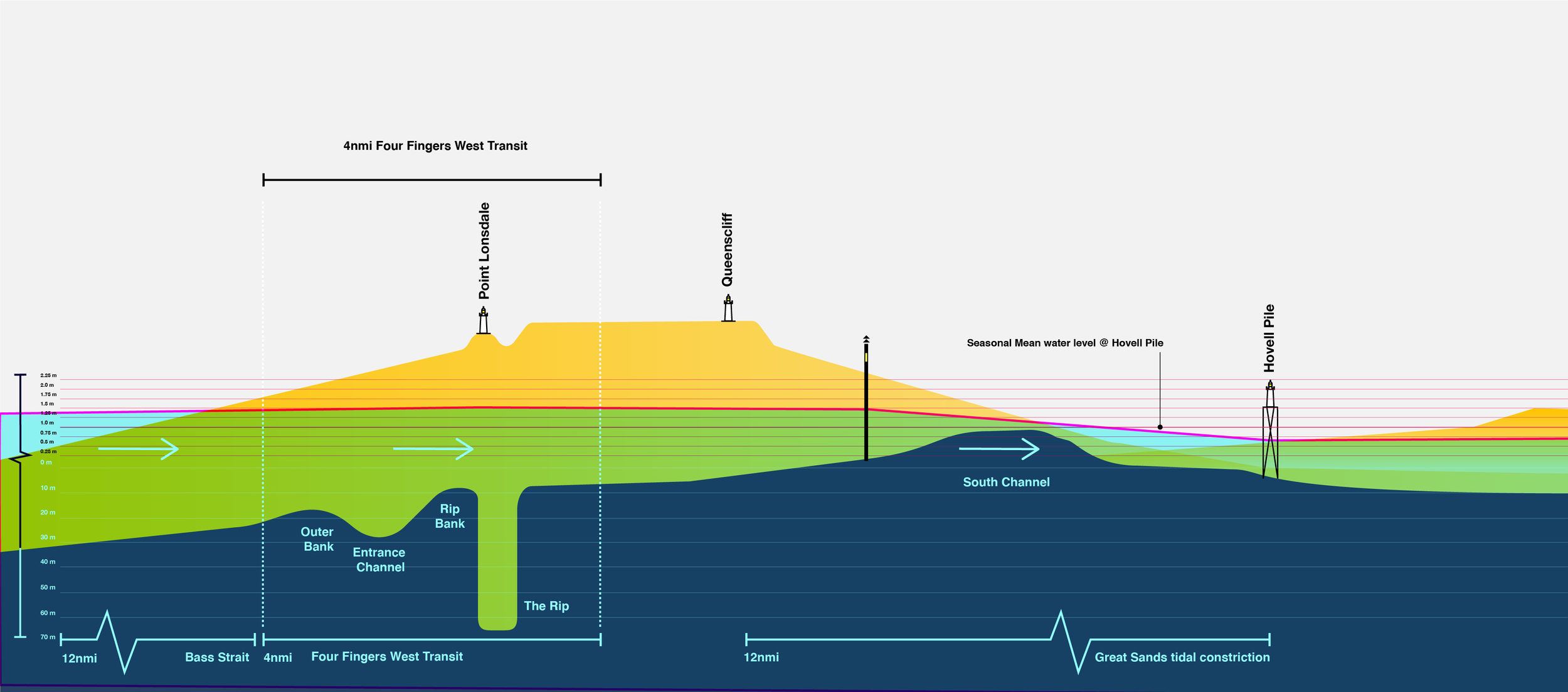
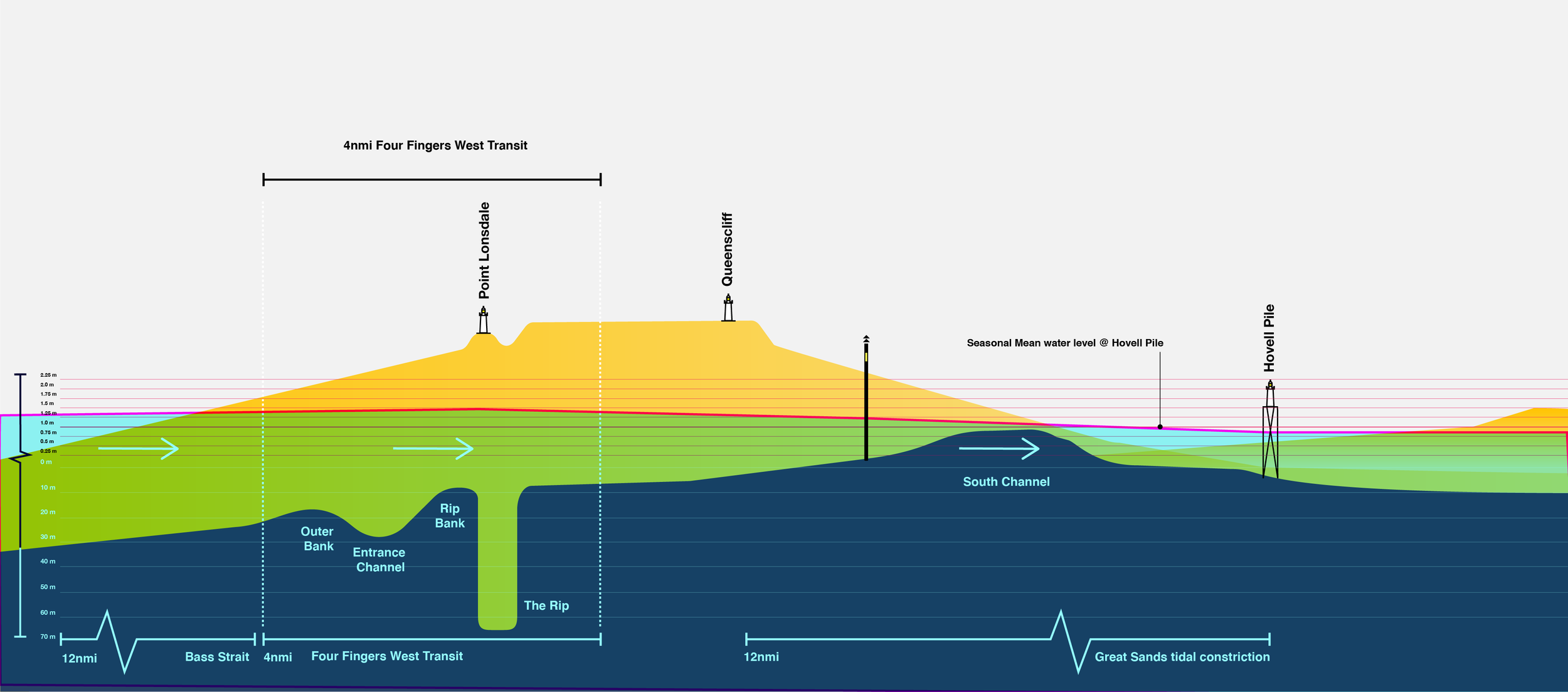
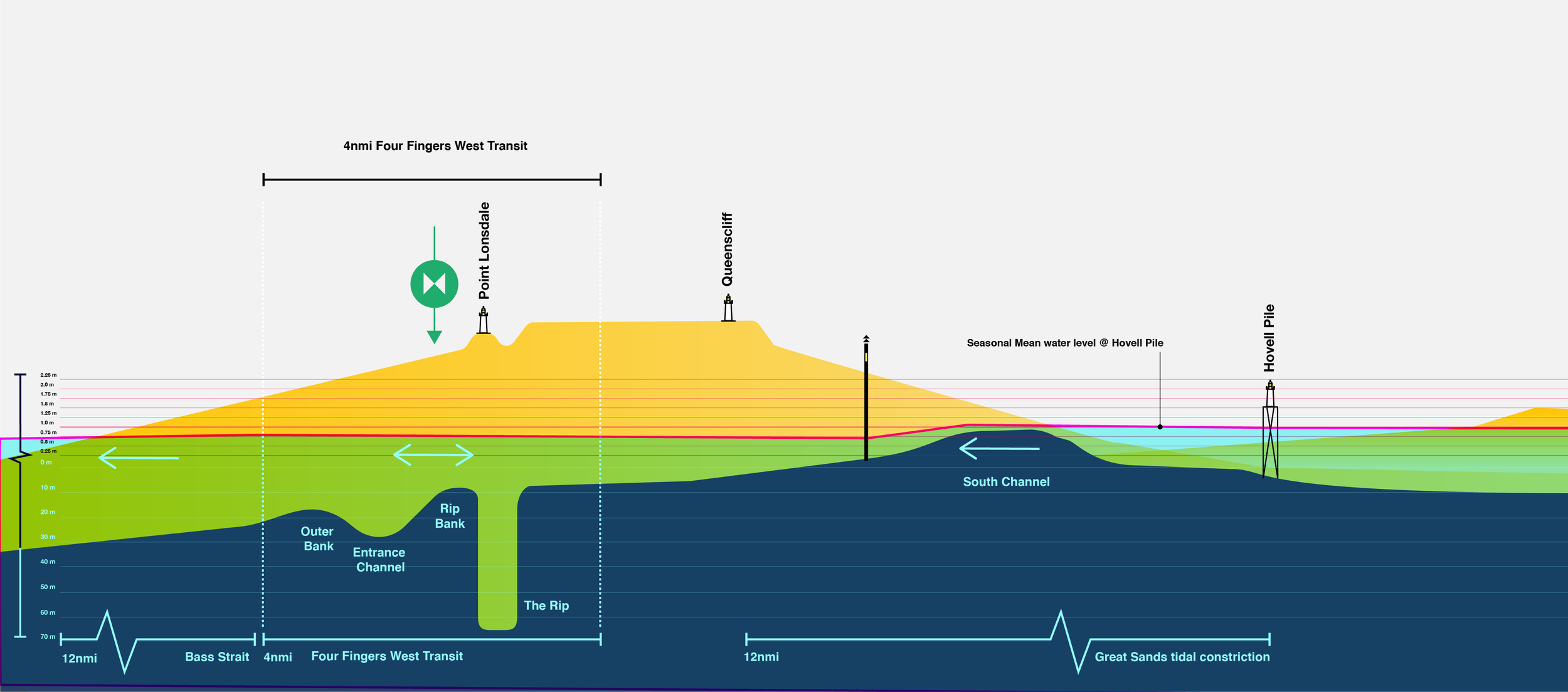
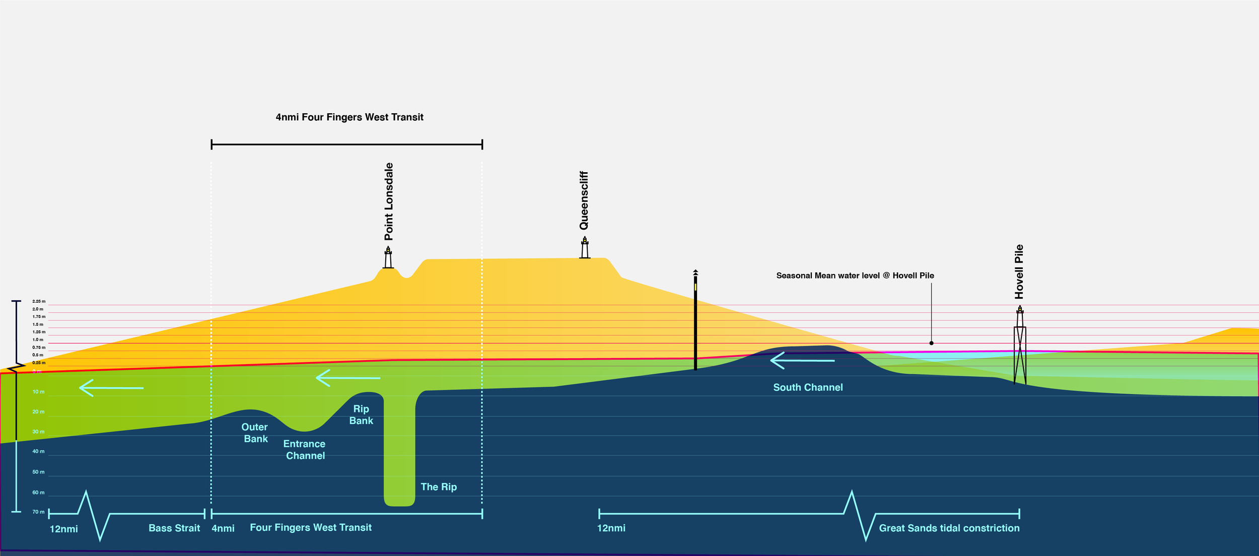
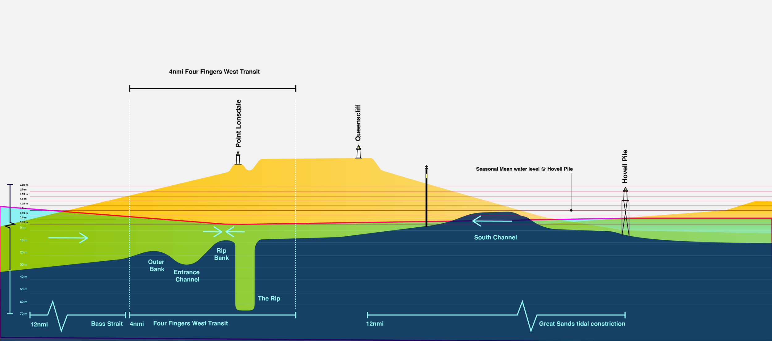
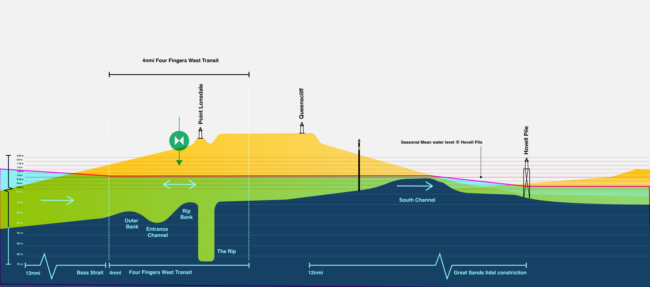
This is a rough diagram built off a model using the realtime data of the flood / slack / ebb levels across the Point Lonsdale, Queenscliff and Hovell Pile monitoring stations. With a bit of work, a simplification of this is a great asset to explain visually why high tide is not slack water.


How can we make this happen?


